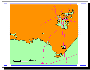
How does the idea of a border involving parts of one country enclosing parts of another and being in turn surrounded by the other country sound? Well it seems that part of the Dutch-Belgian border does exactly this and has done so for 800 years or so, well before either country existed as a separate entity.
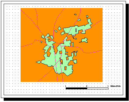
This border was established as part of the Treaty of Maastricht in 1843 (see below). In the area round Baarle (marked B in the above) it proved impossible to come to a definitive agreement. In place of a fixed border (between border posts 214 and 215) each of 5732 parcels of land had their nationality laid down separately. A portion of these parcels form together the space of 20 Belgian exclaves (today's Baarle-Hertog) lying spread around within the territory of the Dutch Baarle-Nassau and separated by 5 kilometers from the Belgian motherland:
The orange portions are part of the national territory of the Netherlands. The green portions, which constitute what we might think of as an inland archipelago, are part of Belgium.
Orange portions within green portions represent exclaves of the Netherlands completely surrounded by Belgian territory which are in turn completely surrounded by the territory of the Netherlands
Just one of those weird things you stumble upon on the internet


 Blog Home : March 2005 : Permalink